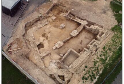
Archeoconsult Ltd.

solutions for archaeology

Menu

Skip to content
  • Home
  • Services overview
  • 3D modeling
  • Software
  • References
  • Contact
  • Good data
    • good data – external
    • good data – internal
      • excavation docu standard (eng.)
Recent Posts

Komárno – Nádvorie Európy. An excavation successfully finished after 20 years…

At the end of this summer, we reopened and definitively completed the research of a set of pottery kilns from the La Tène period in Komárno (southern Slovakia), in cooperation with the Danube Museum...
Read More...

g00d data 02. Iron Age hillforts in Orava region.

I decided to published dataset used for spatial analysis in paper published a few months ago. There are 3 .SHPs applicable for re-modeling and verification of conclusions from the article....
Read More...

g00d data 01. Terrain and documentation standard (manual) published.

We have been published our obligatory terrain and docu standard as basis for terrain database. The manual is to be seen here....
Read More...

Záchranný archeologický výskum v Horní Lukavici

Záchranný archeologický výskum realizovaný subdodávateľsky pre Zapadočeský institut pro ochranu a dokumentaci památek – ZIP o.p.s. (pod vedením Mgr. Martiny Bradovej) v katastri obce Horn...
Read More...

ArcheoConsult – terrain research license

ArcheoConsult spol. Ltd. became, on the basis of a decision of the Ministry of Culture of the Slovak Republic, a certified company for the implementation of archaeological research in Slovakia. We als...
Read More...

Photogrammetric project on Švihov castle started

We started aerial photogrammetry documentation on Švihov castle (western Bohemia) focused on architecture and drainage system....
Read More...

Sacred architecture photogrammetry in Nothern Bohemia

We documented quite destroyer and partially preserved crossroads calvary in Dolní Chobolice (Liběšice) – a small village in Northern Bohemia....
Read More...

Modeling the terrain features for Czech National Heritage Institute

Archeconsult has attented the project of UAV flights, LIDAR scanning and geodesy measuring on spectacular terrain shape (“reduta” terrain fortress) in Western Bohemia....
Read More...

You can’t use LIDAR here, dude…

Back to the good old geodetic craftmanship in the woods where the sunbeam can’t hit the ground....
Read More...
  • 1 of 3
  • 1
  • 2
  • 3
  • Next »
Powered by Professional Theme
  • Home
  • Services overview
  • 3D modeling
  • Software
  • References
  • Contact
  • Good data
    • good data – external
    • good data – internal
      • excavation docu standard (eng.)